CYCLONE PREDICTION—
Reliable Forecasts That Make a Difference
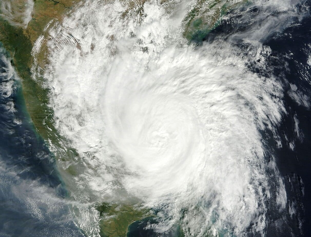
Monitoring Systems
Continuous monitoring of the Indian Ocean and Bay of Bengal for potential disturbances using satellite imagery, ocean buoy data, and weather radar inputs to analyze sea surface temperatures, pressure systems, and wind patterns.
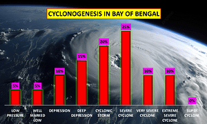
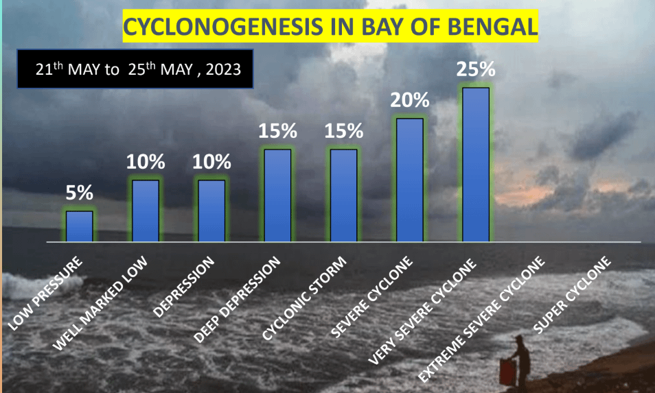
Identifying Cyclogenesis
It involves detecting low-pressure areas and assessing their potential to intensify into depressions or cyclones. This assessment is based on comparing various national and international forecasting models.

Projecting Path, Intensity & Landfall
Utilize multiple forecasting models to determine probable cyclone paths and estimate wind speeds, rainfall potential, storm surge, and wave heights. This enables us to pinpoint expected landfall time and location, often 7 to 10 days in advance.

Issuing Time-Stamped Alerts
We issue initial cyclone alerts up to 168 hours before landfall and refine these alerts at 3-6 hour intervals as the cyclone nears land. Our forecasts include the cyclone’s position, likely intensity, and impact zones.
List of Cyclones that hit India from 2019 to 2024
India’s cyclone season is closely tied to the summer monsoon, with the most intense storms typically forming in the pre-monsoon period (May to June) and the post-monsoon period (October to November).
Here’s the list of the destructive cyclones that have hit India from 2019 till now. Some of the most notable cyclones include :
| Dates | Cyclone Name | Peak Intensity | Affected Areas | Damage (USD) |
|---|---|---|---|---|
| Jan 4 – Jan 8, 2019 | Cyclone Pabuk | Tropical Storm | Andaman Sea | Minimal |
| Apr 26 – May 4, 2019 | Cyclone Fani | Extremely Severe (175 km/h) | Odisha, West Bengal | $8.1 billion |
| Jun 10 – Jun 17, 2019 | Cyclone Vayu | Very Severe (135 km/h) | Gujarat | Moderate |
| Aug 6 – Aug 9, 2019 | Cyclone Hikka | Very Severe (120 km/h) | Oman (minimal impact in India) | Minimal |
| Oct 24 – Nov 2, 2019 | Cyclone Kyarr | Super Cyclonic (220 km/h) | Arabian Sea (no direct impact on India) | Minimal |
| Oct 30 – Nov 7, 2019 | Cyclone Maha | Extremely Severe (150 km/h) | Arabian Sea (no direct impact on India) | Minimal |
| Nov 5 – Nov 11, 2019 | Cyclone Bulbul | Very Severe (110 km/h) | Odisha | Moderate |
| Dec 2 – Dec 7, 2019 | Cyclone Pawan | Tropical Storm | Arabian Sea | Minimal |
| May 16 – May 21, 2020 | Cyclone Amphan | Extremely Severe (260 km/h) | West Bengal | $13 billion |
| May 17 – May 26, 2021 | Cyclone Tauktae | Extremely Severe (210 km/h) | Gujarat | $8.1 billion |
| May 23 – May 26, 2021 | Cyclone Yaas | Very Severe (130 km/h) | Odisha | $610 million |
| Dec 2 – Dec 6, 2021 | Cyclone Jawad | Very Severe (120 km/h) | Andhra Pradesh, Odisha | Minimal |
| May 8 – May 12, 2022 | Cyclone Asani | Very Severe (130 km/h) | Andhra Pradesh | Minimal |
| Dec 9 – Dec 12, 2022 | Cyclone Mandous | Very Severe (120 km/h) | Tamil Nadu | Moderate |
| Oct 22 – Oct 25, 2022 | Cyclone Sitrang | Tropical Storm | Assam, Odisha, West Bengal | Minimal |
| Jun 6 – Jun 15, 2023 | Cyclone Biparjoy | Extremely Severe (195 km/h) | Gujarat | $700 million |
| May 24 – May 28, 2024 | Cyclone Remal | Severe (110 km/h) | Odisha | $600 million |
| Aug 25 – Sep 3, 2024 | Cyclone Asna | Tropical Storm | Madhya Pradesh | $30 million |
| Oct 24 – Oct 25, 2024 | Cyclone Dana | Expected to be Severe | Odisha, West Bengal | $72 million (Rs. 600 crore) |
| Nov 25-Nov 27, 2024 | Cyclone Fengal | Expected to be Deep Depression | Tamil Nadu and Puducherry | TBD |
History of Timely Cyclone Forecast
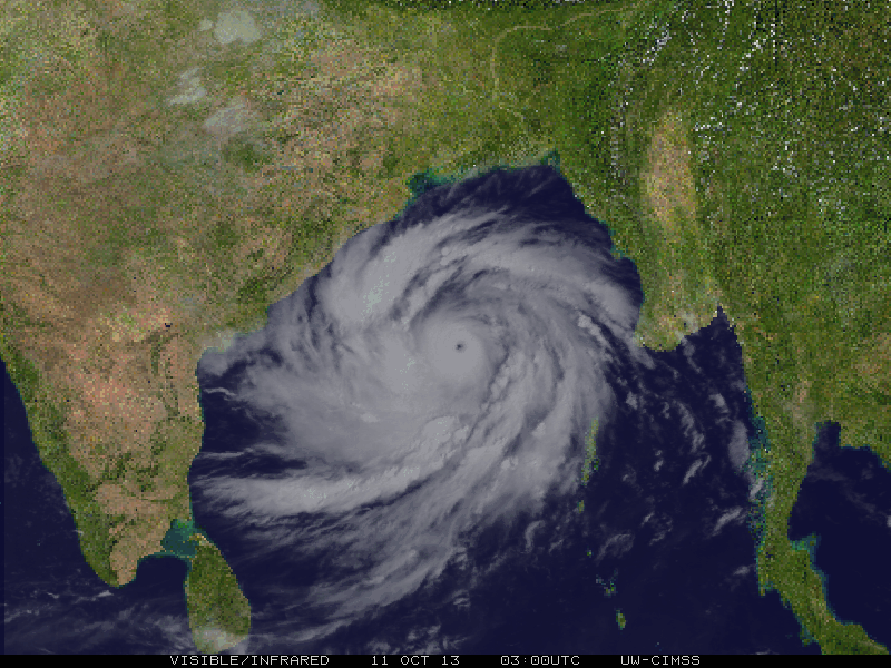
2020 – Cyclone Amphan
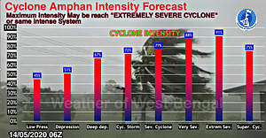
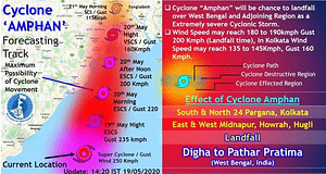
Super Cyclone Amphan: A Case Study (Meteora Perspective)
Meteora Weather Service was instrumental in early prediction and continuous monitoring of Cyclone Amphan.
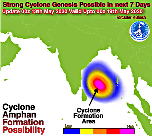
Pre-Cyclone Analysis: Using sea surface temperature anomalies, wind shear studies, MJO analysis, and multimodal model assessments, Meteora identified a strong potential for cyclone formation as early as 7 days before landfall.
Cyclone Watch Issued:
May 13, 2020: Meteora tracked a developing low-pressure area.
May 15–16: Issued warnings as it evolved into a depression and a severe cyclone.
May 18: Declared it a Super Cyclone.
May 20: Accurately forecasted landfall near Gangasagar, West Bengal, at around 2:30 PM.
Key Forecasting Highlights:
Real-time satellite surveillance
Advanced numerical weather prediction models
Accurate wind speed and trajectory forecasts
Proactive alert dissemination across impacted areas,
History of Timely Cyclone Forecast
2021 – Cyclone Yaas
Cyclone Yaas: A Case Study by Meteora
Cyclone Yaas was a severe cyclonic storm that impacted Odisha, West Bengal, and neighboring regions in late May 2021. Wind speeds reaching up to 150 km/h caused significant damage worth USD 2.99 billion and resulted in 20 fatalities.
Early Detection and Forecasting by Meteora
Key Timeline:
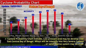
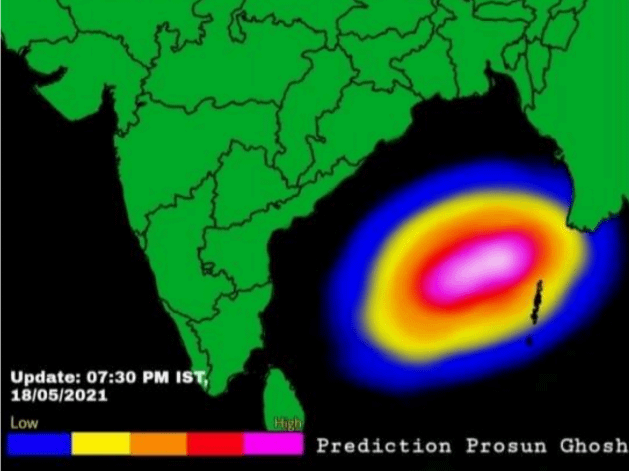
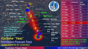
21st May 2021: Formation of a low-pressure system.
23rd May 2021: Expected development into a deep depression.
25th May 2021: The system intensified into a Very Severe Cyclonic Storm.
26th May 2021: Landfall at Inchudi, Balasore (Odisha), with peak wind speeds of 150 km/h.
Factors Leading to Cyclone Formation:
High Sea Surface Temperatures (30–34°C) across the Bay of Bengal.
Favorable MJO (Madden-Julian Oscillation) phases enhance convection.
Low Wind Shear and High Tropical Cyclone Heat Potential.
Neutral ENSO and IOD conditions make the Bay of Bengal highly conducive for cyclogenesis.
📍 Impacted Regions :
| Region | Effects |
|---|---|
| Odisha | Direct landfall, heavy destruction |
| West Bengal | Widespread hazardous weather |
| Jharkhand, Chhattisgarh | Partial impact with heavy rains and winds |
👉 Read the full document. – Cyclone Yaas
History of Timely Cyclone Forecast
2023 – Cyclone Michuyang
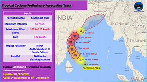
Cyclone Michaung: Cyclone Update by Meteora
On December 2, 2023, the Meteora Weather Service closely tracked the development of a deep depression over the southwest Bay of Bengal. With favorable conditions like high sea temperatures, low wind shear, and active MJO, it was projected to intensify into Cyclone Michaung, impacting major parts of India’s east coast.
Early Detection and Forecasting by Meteora
Key Timeline:
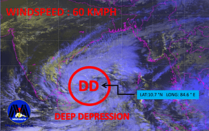
2nd December: Formation of a deep depression at 10.7°N, 84.6°E.
Within 24 Hours: Predicted to strengthen into a cyclonic storm.
By 3rd–4th December: Expected intensification into a severe cyclonic storm.
Landfall: Between 4th and 5th December near the Nellore–Visakhapatnam coast in Andhra Pradesh.
Maximum Intensity Expected:
At Sea: Winds 100–110 kmph (gusts up to 120 kmph)
At Landfall: Cyclonic storm to Severe Cyclone strength
📍 Forecasted Impact Zones:
| State | Impact Window | Expected Effects |
|---|---|---|
| Andhra Pradesh | 3rd–5th Dec | Extreme heavy rain, 100+ kmph winds |
| Tamil Nadu | 3rd–5th Dec | Heavy rain, 70 kmph winds |
| Odisha | 4th–6th Dec | Very heavy rain, 90+ kmph winds |
| West Bengal | 5th–7th Dec | Moderate rain, 30–40 kmph winds |
👉 Read the full document. Cyclone Michuyang
History of Timely Cyclone Forecast
2024 – Cyclone Remal
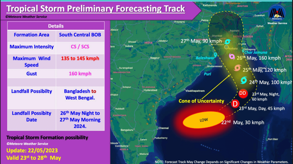
Cyclone Rimel: Pre-Cyclone Watch & Forecast (Meteora Perspective)
Overview: In late May 2024, Meteora Weather Service identified and tracked the development of a significant tropical system in the Bay of Bengal—eventually projected to become Cyclone Rimel. Thanks to early analysis and predictive modeling, Meteora issued crucial early warnings across potentially affected regions.
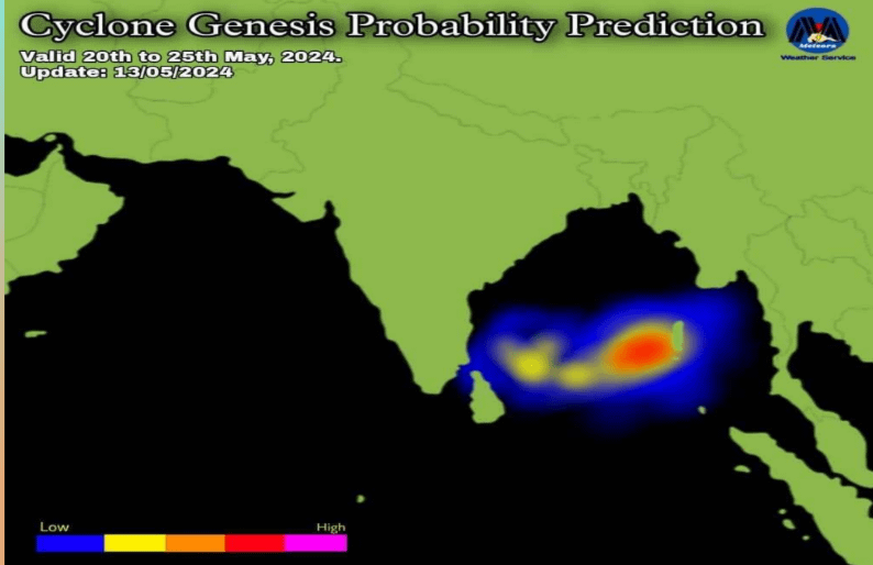
Early Cyclone Detection by Meteora – Initial Alert (22nd May 2024):
A well-marked low-pressure system over the west-central Bay of Bengal, supported by favorable meteorological conditions like
High sea surface temperature (SST)
Favorable Madden-Julian Oscillation (MJO)
Low vertical wind shear
High tropical cyclone heat potential
This led Meteora to predict cyclogenesis within 48 to 72 hours, with high confidence (70–100%).
Forecast Highlights:
Depression Date: 23rd May 2024
Cyclone Formation: 24th May 2024
Landfall Date: 26th–27th May 2024
Landfall Area: West Bengal & adjoining Bangladesh
Max Wind Speed: 135–145 km/h (Gusts up to 160 km/h)
Projected Intensity: Very Severe Cyclonic Storm
Predicted Impact Zones (25th–27th May):
| Region | Forecasted Impact |
|---|---|
| West Bengal | 90+ kmph winds, widespread heavy rain |
| Odisha, Jharkhand, Tripura, Mizoram | 60–90 kmph winds, heavy rain |
| Other NE States, Bihar, UP, A&N Islands | Light to moderate rainfall, 40–60 kmph winds |